La Perouse, SYDNEY, AUSTRALIA


On the weekend, I sometimes spent my weekend at La Perouse, southern part of Sydney. La Perouse is a suburb in south-eastern Sydney, in the state of New South Wales, Australia. La Perouse is located about 14 kilometres south-east of the Sydney central business district, in the City of Randwick.


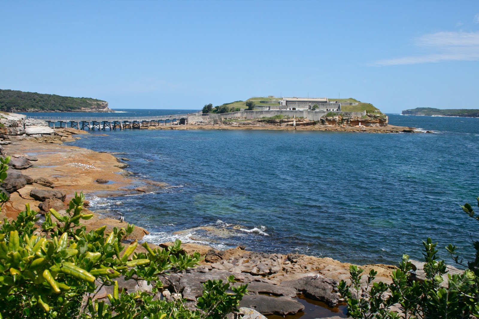
The La Perouse peninsula is the northern headland of Botany Bay. It is notable for its old military outpost at Bare Island and the Botany Bay National Park. Congwong Bay Beach, Little Congwong Beach, and the beach at Frenchmans Bay provide protected swimming areas in Botany Bay. La Perouse is one of few Sydney suburbs with a French title, another being Sans Souci. Kurnell is located opposite, on the southern headland of Botany Bay.


La Perouse was named after the French navigator Jean-François de Galaup, comte de La Pérouse (1741-88), who landed on the northern shore of Botany Bay west of Bare Island in January 1788. La Pérouse’s two ships sailed to New South Wales after some of his men had been attacked and killed in the Navigator Islands (Samoa). La Pérouse arrived off Botany Bay on 24 January just six days after Captain Arthur Phillip (1738-1814) had anchored just east of Bare Island, in H.M. Armed Tender Supply. On 26 January 1788, as Arthur Phillip was moving the First Fleet around to Port Jackson after finding Botany Bay unsuitable for a Settlement, La Pérouse was sailing into Botany Bay,anchoring there just eight days after the British had.

Visitors can learn about the indigenous significance of the area from the Aboriginal people of the area, with boomerang-throwing demonstrations often held on weekends and Aboriginal guided tours operating from Yarra Bay House during the week. Aboriginal artefacts are produced and sold by locals. An outdoor reptile show is also a well-known tourist attraction in the pit, at The Loop, on Sunday afternoons. The reptile shows were begun by George Cann in the early 1920s and the tradition has been continued by members of the Cann family ever since.

La Perouse has a few cafes and restaurants around the historic precinct, close to Frenchmans Bay.

SOURCE: wikipedia
Photo: personal collection and google.com

The TWIN TOWERS KUALA LUMPUR MALAYSIA


The Petronas Twin Towers (Malay: Menara Berkembar Petronas) (also known as the Petronas Towers or just Twin Towers[clarification needed]), in Kuala Lumpur, Malaysia were the world's tallest buildings from 1998 to 2004, when their height was surpassed by Taipei 101. The towers remain the tallest twin buildings in the world.

The Petronas Twin Towers were the tallest buildings in the world until Taipei 101 was completed in 2004, as measured to the top of their structural components (spires, but not antennas). Spires are considered integral parts of the architectural design of buildings, to which changes would substantially change the appearance and design of the building, whereas antennas may be added or removed without such consequences. The Petronas Twin Towers remain the tallest twin buildings in the world.

Source: wikipedia
Photo: personal collection

BATU CAVE, Kuala Lumpur MALAYSIA


We were visiting this site on February 2010. We were just taking pictures, enjoy Teh Tarik and buying some souvenirs. No time to climb up to the cave. Batu Caves is a limestone hill, which has a series of caves and cave temples, located in Gombak district, 13 kilometres (8.1 mi) north of Kuala Lumpur, Malaysia. It takes its name from the Sungai Batu or Batu River, which flows past the hill. Batu Caves is also the name of the nearby village.

The cave is one of the most popular Hindu shrines outside India, dedicated to Lord Murugan. It is the focal point of Hindu festival of Thaipusam in Malaysia. The limestone forming Batu Caves is said to be around 400 million years old. Some of the cave entrances were used as shelters by the indigenous Temuan people (a tribe of Orang Asli).

As early as 1860, Chinese settlers began excavating guano for fertilising their vegetable patches. However, they became famous only after the limestone hills were recorded by colonial authorities including Daly and Syers as well as American Naturalist, William Hornaday in 1878.

Batu Caves was promoted as a place of worship by K. Thamboosamy Pillai, an Indian trader. He was inspired by the 'vel'-shaped entrance of the main cave and was inspired to dedicate a temple to Lord Muruga within the caves.

In 1891, Pillai, who also founded the Sri Mahamariamman Temple, Kuala Lumpur, installed the murti (consecrated statue) of Sri Subramania Swamy in what is today known as the Temple Cave. Since 1892, the Thaipusam festival in the Tamil month of Thai (which falls in late January/early February) has been celebrated there.

Wooden steps up to the Temple Cave were built in 1920 and have since been replaced by 272 concrete steps. Of the various cave temples that comprise the site, the largest and best known is the Temple or Cathedral Cave, so named because it houses several Hindu shrines beneath its 100 m vaulted ceiling.

Rising almost 100 m above the ground, Batu Caves temple complex consists of three main caves and a few smaller ones. The biggest, referred to as Cathedral Cave or Temple Cave, has a 100 m-high ceiling, and features ornate Hindu shrines. To reach it, visitors have to climb a steep flight of 272 steps.

At the base of the hill are two more cave temples, Art Gallery Cave and Museum Cave, both of which are full of Hindu statues and paintings. This complex was renovated and opened as the Cave Villa in 2008. Many of the shrines relate the story of Lord Murugan's victory over the demon Soorapadam. An audio tour is available to visitors.

The Ramayana Cave is situated to the extreme left as one faces the sheer wall of the hill. On the way to the Ramayana Cave, there is a 50-foot (15 m) tall murti of Hanuman and a temple dedicated to Hanuman, the noble monkey devotee and aide of Lord Rama. The consecration ceremony of the temple was held in November 2001.

The Ramayana Cave depicts the story of Rama in a chronicle manner quite effectively. The cave is well lit and allows the visitor to stroll leisurely viewing the depictions along the irregular walls of the cave. One might experience the feeling that one is strolling through the giant intestines of the mighty demon, Kumbhakarann, brother of King Ravana of Lanka.

A 42.7m (132 feet high) high statue of Lord Muruga was unveiled in January 2006, having taken 3 years to construct. It is the tallest Lord Muruga statue in the world.

SOURCE: wikipedia
Picture: personal collection

THREDBO VILLAGE, Snowy Mountain, NEW SOUTH WALES


International Students Services (ISS) at the University of New South Wales Sydney, organized a trip to Thredbo Village Snowy Mountain on the winter breaks 2002. We all were having fun that time. We were staying at Jindabyne hotel next to the lake that time. Thredbo Village Popular skiing destination and starting point for the walk to the top of Mount Kosciuszko. Unlike the other locations in the Kosciuszko area, Thredbo Village is legitimately an all year resort. This delightful township, located below the snowline on the Alpine Way 97 km from Cooma, 498 km from Sydney and 1370 m above sea level, is as close as Australia will ever get to a genuine alpine settlement. The chalets, the narrow winding streets, the skiing and bracing 'mountain walks' ambience all contribute to a feeling that this is like no other town in Australia.

Thredbo came into existence as the Thredbo gold diggings in the 1860s and while the river bed wasn't lined with nuggets (as it was at Kiandra) the miners persisted until the 1930s. In the 1950s, as the Alpine Way was built, more and more skiers came to the area to ski the slopes of Crackenback. The village slowly developed so that now it is one of the most attractive locations in the mountains.
Snow and summer activities.

Thredbo has a reputation as a ski resort (and not always a brilliant one as the snow is prone to run out before the slope does - although the acquisition of snow making equipment should remove these problems) the local businesses have made a concerted effort to make the summer attractions as interesting as the winter ones. The village boasts a golf course, tennis courts, mountain bicycling facilities, horse riding, and for the really adventurous, paragliding from Crackenback Mountain.

For the less adventurous, or even the passer by, a summer trip on the ski lift is a must. It rises 595 metres from the valley floor over some dramatic scenery and at the top (where there's a restaurant) the views over the valleys and the ranges of the Snowy Mountains are spectacular. For those determined to reach the top of the continent the walk to the top of Mount Kosciuszko is a pleasant 12 km (6 km each way) and usually takes around 4-6 hours. This is not a difficult walk. On New Years Day 2000, when we bravely made the journey to the top of the continent,we were beaten by a one-legged man.

The walk from the ski lift is not difficult. In fact, in order to protect the alpine flora, the National Parks and Wildlife Service have built metal walkways which make the walk even easier than it already is. National Parks have published a 37 page booklet titled Beyond the Snow Gums: The Alpine Area - Kosciuszko National Park which provides detailed information on the walk. The Information Centre, located near the ski lifts, also has locally produced brochure which outlines a number of walks in the area including some easy ones around the village as well as a number on the mountain tops.

SOURCE: www.smh.com.au/travel
Picture: personal collection

The Centennial Park, SYDNEY


The beauty of Centennial Park in winter. Sometimes in the afternoon, my friend and I were jogging around this park. It's not too far from my apartment in Kingsford. Centennial Park is a large public, urban park that occupies 220 hectares in the Eastern Suburbs of Sydney in the state of New South Wales, Australia. Centennial Park is located 4 kilometres south-east of the Sydney central business district, in the City of Randwick.

Centennial Park is also a small residential suburb, on the western fringe of the parkland, which is part of the local government area of the City of Sydney. The government began plans for a celebratory park in 1886 and passed an Act of Parliament in the following year. Some of the grandiose plans for the area, such as a museum and a national convention building, never eventuated.

Centennial Park was dedicated by Sir Henry Parkes in January 1888 to celebrate the first 100 years of European settlement in Australia and described by him as 'emphatically the people's park'. The Governor-General, Lord Hopetoun dedicated the park 'to the people of New South Wales forever'.

Centennial Park is the largest of the three parks that make up Centennial Parklands. It is 2.20 square kilometres in area, originally swampland, known as Lachlan Swamps and is located adjacent to another large public space, Moore Park. It is administered by the Centennial Park & Moore Park Trust, a NSW Government agency whose responsibilities cover low-lying wetlands, ornamental lakes, pine and native forests, expanses of grass, to playing fields, a golf course, tennis and netball courts and the Entertainment Quarter at nearby Moore Park. It is one of Australia's most famous parks and is listed on the Register of the National Estate.

The Federation Monument, which consists of the Commonwealth Stone (1901) and the Federation Pavilion (1988), is significant as the site of the official ceremony to mark the Federation of Australia and the inauguration of the Commonwealth of Australia on 1 January 1901.

Grand Drive is the circular main road through the park. It runs for 3.8km and is part of the Sydney Marathon course, which was used in the 2000 Summer Olympics. The drive is separated into five concentric circles, with the outer track used for cycling or rollerblading, fourth largest for car driving, third for car parking and many trees, the second is a paved pathway for walking, also used for running, the smallest being a dirt track for horseriding. Ranger's cottage, designed by Walter Liberty Vernon, an example of the Federation Bungalow style

Source: wikipedia
Picture: personal collection

The Circullar Quay, SYDNEY


These pictures were taken around 2002 - 2004 when I was studying in the University of New South Wales, Sydney, Australia. I still have a lot of pictures around the Circullar Quay, only these 4 pictures I think good to share. Circular Quay is the hub of Sydney Harbour, situated at a small inlet called Sydney Cove, the founding site for Sydney and Australia. It is a stepping-off point for most attractions based around the harbour and an exciting place to be on a warm summer's day. The quay is a vibrant, bustling place with ferries leaving every few minutes to different parts of the harbour, including Manly, Watsons Bay, Mosman and Taronga Park Zoo. There are great views of the Harbour Bridge, a short distance away.

On the southern side of Circular Quay is a walkway that leads to the Sydney Opera House and Royal Botanical Gardens; while on the northern side, a short walk along lovely landscaped walkways takes you to the Harbour Bridge and The Rocks, one of the oldest, most attractive and most interesting parts of Sydney. Circular Quay is at the foot of the central business district and the older, historic end of the city. Buses depart here for Bondi and the eastern suburbs.

There is a major railway station at the quay, which is part of the underground City Circle , which skirts around the CBD. Alongside the ferry terminals are a number of small outdoor cafes and the area is a magnet for buskers of every description.

Source; sydney.com.au
Picture: personal collection

The Esplanade, SINGAPORE


With my friends, wandering around the esplanade before exploring the shopping centre and mall. Merlion Statue is a symbol of Singapore and one of the most statue photographed in the world. It guards the entrance to the Singapore River. The merlion is a mythological creature with the head of a lion and the body of a fish. The world Merlion is a combination of mermaid and lion.

Merlion is located near Esplanade Drive; near Fullerton Road; near Fullerton Road; 0.2 kilometre away from Boat Quay; 0.2 kilometre away from Battery Road; Merlion is geographically located at latitude (1.2866 degrees) 1° 17' 11" North of the Equator and longitude (103.8546 degrees) 103° 51' 16" East of the Prime Meridian on the Map of Singapore or JB.

The locations related to Merlion are represented by the nearest distances for a beam of light to travel and may not be nearest by road. For example, Merlion is located 0.1 kilometre from One Fullerton. Merlion is located 0.1 kilometre from The Fullerton Waterboat House. Merlion is located 0.2 kilometre from Old Merlion Park. Merlion is located 0.2 kilometre from Esplanade Bridge. Merlion is located 0.2 kilometre from Fullerton Hotel.

Source: various source on the web.
Pictures: personal collection

PUTRA MOSQUE, Putrajaya KUALALUMPUR


When I was in Putra Mosque, at Putrajaya area in Kualalumpur. Putrajaya (Jawi: ڤوتراجاي) is a planned city, located south of Kuala Lumpur, that serves as the federal administrative centre of Malaysia. The seat of government was shifted in 1999 from Kuala Lumpur due to the overcrowding and congestion there. Nevertheless, Kuala Lumpur remains as Malaysia's national capital (as the seat of Parliament) as well as the country's commercial and financial centre. Putrajaya was the brainchild of former Prime Minister Tun Dr Mahathir Mohammad who was in power then. In 2001, Putrajaya was made a Federal Territory, increasing the number of federal territories to three. Kuala Lumpur and Labuan are the other two.

Named after the first Malaysian Prime Minister, Tunku Abdul Rahman Putra the city is situated within the Multimedia Super Corridor, beside the also newly developed Cyberjaya. The development started in 1995 and today major landmarks are completed and the population is expected to grow in the relatively new city. The "jaya" (जय) part of the city's name means "victory" in Sanskrit.

The vision to have a new Federal Government Administrative Centre to replace Kuala Lumpur as the administrative capital emerged in the late 1980s, during the tenure of Malaysia's 4th Prime Minister, Dr. Mahathir Bin Mohamad. The new city was proposed to be located between Kuala Lumpur and the new KL International Airport (KLIA).

The Federal government negotiated with the state of Selangor on the prospect of another Federal Territory and in the mid-1990s, the Federal government paid a substantial amount of money to Selangor for approximately 11 320 acres (46 km²) of land in Prang Besar, Selangor. As a result of this land purchase, the state of Selangor now completely surrounds two Federal Territories within its borders, namely Kuala Lumpur and Putrajaya.

Planned as the garden and intelligent city, 38% of the area is reserved for green areas by emphasizing the enhancement of natural landscape. A network of open spaces and wide boulevards were incorporated to the plan. Construction began in August 1995 and it was Malaysia's biggest project and one of Southeast Asia's largest with estimated final cost of US$ 8.1 billion. The entire project was designed and constructed by Malaysian companies with only 10% of the materials imported.

In 2007, the population of Putrajaya was estimated to be over 30,000, which comprised mainly government servants.

Source: Wikipedia
Picture; personal collection

Wat Arun, BANGKOK, THAILAND


My friends and I was visiting this place in February 2010 on our Thailand tour. In Thiland we visited Wat Arun, Chao Phraya river, and many other tourist destinations. This Wat Arun temple is one of the favorite destination for tourists in Bangkok. Wat Arun (Temple of the Dawn) is located on the western bank of the Chao Phraya River opposite Wat Pho and is the standout temple in Bangkok. Construction of the tall prang and four smaller ones was started by King Rama II (r. 1809-1824) and completed by King Rama III (r. 1824-1851). The towers are supported by rows of demons and monkeys. Very steep and narrow steps lead to a balcony high on the central tower. The circumference of the base of the structure is 234 meters, and the central prang is 250 foot high. The central balcony commands an impressive view of Bangkok across the river. From here you can see the Grand palace, the Temple of the Emerald Buddha and the spacious Wat Pho.

The towers of Wat Arun are built of brick covered with stucco. The decorations are unique; thousands of pieces of multicoloured Chinese porcelain. In niches in the central tower are green figures of the God Indra seated on Erawan, the traditional Thai three-headed elephant. Niches in the smaller towers contain figures of the Moon God, on a white horse. The trident of Shiva extends from the top of each tower.
Wat Arun ("Temple of the Dawn") in Bangkok is a Khmer-style Buddhist temple and major landmark on the west bank of the Chao Phraya River.

@from various sources on the Web
@Photo: personal collection

abcs